Ice and glaciers

Ice forms when water in the liquid state freezes. Freezing temperature depends on the content of salt dissolved in the water: at normal atmospheric pressure, it is 0° C for pure water, not greatly different for fresh water and it drops to -1.8°C in the case of sea water. When temperatures drop below freezing point, water turns into the solid state. This is true for water that flows freely on the Earth’s surface as also for stretches of water such as lakes, rivers, seas , and also for water trapped in wedges in rocks and in pores in the ground, where ice lenses and veins form. Running water, due to its movement, freezes more slowly than still water, for this reason it is easier in winter to see the formation of ice on the surface of small stretches of still water, while the waterways are not frozen.
Since most of the Earth’s ice does not come from frozen pure water, the ice we see generally consists of ice crystals mixed with a number of impurities, including dissolved salts absorbed in the ice crystal network (like sea water salts in sea ice), fragments of debris, atmospheric dusts, fragments of rock or soil trapped among the crystals, and minute air bubbles imprisoned during the freezing phases or as the snow was transformed into ice. The study of these impurities enables us to obtain important information about the formation processes and about where the ice comes from and even about the composition and temperature of the atmosphere at the time of ice formation.
Related topic


Snow transforms: glacier ice
The formation of the ice of a glacier begins with snow deposition. Snow, with its star or hexagon shaped crystals, contains a great quantity of air, and has a very low density (this is why we sink in so easily, furthermore because of this, snow has a great capacity to absorb sounds, a snowy landscape seems strangely “silent”). As soon as it falls to the ground, snow begins a transformation that leads to the modification of the shape and size of the crystals and a progressive decrease in the number and size of the empty spaces, increasing the density.
The physical properties of ice
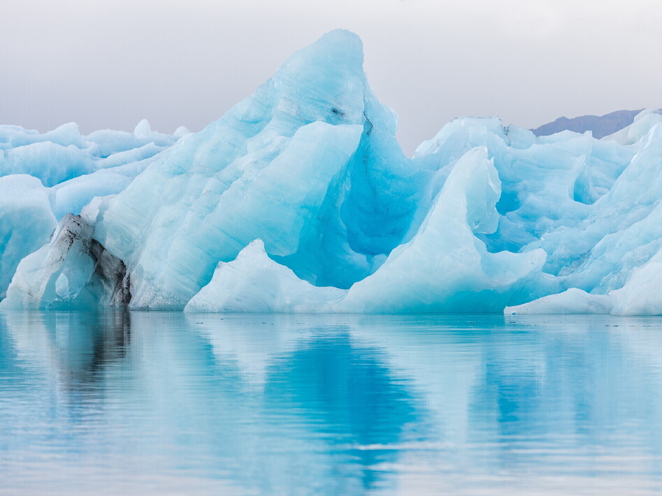
Ice has a singular property, which is apparently banal, but which has important repercussions on the life of the entire planet. While most substances decrease in volume when changing from the liquid state to the solid state, the property of water is that it is less dense in the solid state than in the liquid state: in fact, maximum density of water is reached at a temperature of 4°C. This implies that ice is lighter than an equivalent quantity of liquid water, therefore ice floats on water: this can be seen when sipping a drink in a glass full of ice cubes. However, in nature, the same phenomenon can be seen in the icebergs and in the formation of sea and lake ice.
How much does ice weigh?
Like an object that floats on water, analogously the Earth’s crust “floats” in equilibrium on the viscous plastic rocks of the underlying mantle. A decrease in the weight of the crust, caused, for example by the removal of rocks due to erosion, makes the rocks lighter and the crust rises, while an increase in the weight makes the crust sink even deeper into the “soft” and viscous mantle, by a process called isostasy. The formation of thick layers of ice, (as in the glaciations of the past), causes an overload on the ice covered crust, and the result is that it sinks into the mantle, various hundreds of metres, in some cases even below sea level.
The mass of ice that forms a glacier is not a static and homogeneous mass: the ice has different characteristics in various points of the glacier, and behaves differently depending on the compactness, density, temperature within and at the base of the glacier, and the characteristics of the bedrock the glacier rests on. On the surface of every glacier, therefore, it is possible to identify different areas, where different processes are taking place, which mould the shape of the glacier and determine its behaviour. In every glacier it is possible to identify two fundamental areas : the accumulation area where the snow that falls in winter is preserved during the hot season, which is the area where the glacier receives the supply of snow that is necessary for its survival, and the ablation area, where, instead, there is a loss of ice, mainly due to the melting of the snow that fell during the previous winter season, and the ice left bare after snow melting, but also due to collapse and detachment of material from the glacier body, as in the case, for example, of the formation of icebergs. Therefore there are areas of the glacier where ice is produced, and areas where, on the contrary, ice is destroyed and moved away. The two areas are easy to recognize in summer : the accumulation area in fact has a white surface covered with snow and firn, while the ablation area shows weathered ice, whose appearance is generally “dirty” due to the presence of rock debris that appear on the surface of the ice. The extension and importance of these two areas characterize every glacier and condition their behaviour. The extension of the two areas is not fixed in time – in fact they are separated by an equilibrium line that coincides, approximately, with the perennial snow limit. Since this limit varies greatly depending on the climatic conditions, short term and long term variations in the climate greatly influence its position, and consequently the magnitude of the accumulation and ablation area. The body of a mountain glacier is usually confined by the rocky mountain slopes surrounding it, generally on almost all the sides, however there usually is a non-confined side, where the glacier is free to expand or retreat. This is the glacier front, that indicates the limit beyond which the glacier cannot exist, because here, simply, ablation destroys all the ice. One of the most evident characteristics of a glacier, which differentiates it from a snow deposit, is that ice moves, sliding toward the valley, under the pressure of its own weight. In this manner the ice lost in the ablation area is continually replaced by new ice that forms in the accumulation area and is transported downstream by glacier movement.
Related topic
Glacier movement
Glacier movement is not uniform throughout its mass and it is not even constant in time. The speed of the movement is slower near the walls and the base, where the glacier is slowed down by friction with the bedrock, and maximum in the central zones, where friction is minimum and ice thickness is maximum. Different speeds may be noted also at the confluence of two ice snouts, usually marked by a “floating” medial moraine, a long strip of debris on the sides of the glacier snouts along the entire length of the ablation area. If there is melted water at the base, the glacier moves more rapidly.
The delicate equilibrium of glaciers
Therefore in order to evaluate the “state” of a glacier, in particular if the glacier shows an advance or a retreat, it is not sufficient to evaluate the variations in the position of the front, but the delicate equilibrium of the snow supply, i.e. the formation of new ice, and the loss of ice in the ablation area must be considered. In other words, it is necessary to evaluate the variations in the volume of the glacier, studying the “balance” of these two factors, calculating what researchers call “mass balance”. Practically this means measuring supply and loss, as in a company balance-sheet, and to find, from the difference, if the volume of the glacier is increasing or decreasing.
The “material” ice
Ice has singular physical properties that condition all the processes that take place on the surface and within a glacier. At ambient pressure, ice is a very fragile material. If it is subjected to mechanical stress such as compression or distortions it reacts and it forms fractures and breaks in a fragile manner (to verify this try dropping an ice cube: it will break into a myriad of splinters that will melt rapidly on your kitchen floor). In high pressure conditions, as for example within a glacier, or as a result of stress applied very slowly, on the contrary, ice is plastic, and deforms and twists continuously, without forming any fractures.
A large conveyor belt
Glacier movement, friction with the rock along the sides and on the bottom, falling material from the surrounding sides, dust brought by wind, animal carcasses, waste left by man, including war relics and the bodies of unfortunate soldiers or mountain climbers: everything can be “captured” and swallowed by the ice of a glacier, on the surface or within. The movement of a glacier, described before as a sliding downstream movement, is actually more complex and it contributes to letting debris penetrate deeply in the accumulation area, and to bringing them out in the ablation area, where also melting process collaborates in uncovering them.
White and black glaciers
The amount of debris inside and on the surface of a glacier is very variable and depends on glacier movement, on the type of bedrock it moves on, and on the shape and geological characteristics of the walls overlooking the glacier. Particular types of rocks, sensitive to weathering processes such as cryoclast weathering freeze-thaw weathering, or where the sides are subjected to frequent landslides and falling and flowing of debris, can provide large amounts of detrital material, which then cover the glacier surface.
Who went this way?
All glaciers leave traces of their passage, traces that may remain even for thousands or millions of years. By studying present day glaciers, geologists are able to easily recognize the evidence of the existence of ancient glaciers. A glacier, moving and sliding on the bedrock leaves two different types of traces: it may deposit material carryed inside and on its surface, thus giving rise to ice deposits accumulated in characteristic features that are easy to recognize, or it may erode the rocks it is moving on, leaving smooth and polished surfaces.
Related topic
Glacier Mass Balance
Calculation of the Glacier Mass Balance is a more complex operation – in fact a series of measurements and surveys must be carried out. First of all, the quantification of the additional constituents, measuring the amount of precipitations on the ice, also bearing in mind the so-called “hidden precipitations”, such as hoarfrost, or ice formed by sublimation, and contribution by avalanches. In order to do this, the height of snow precipitation, during winter and spring, in fixed, special points of the glacier, is measured.
Measurement of the speed
The measurement of the speed at which a glacier is moving was certainly one of the first operations carried out by the first glaciologists in the 19th century, along with the observation of the front variations. In order to measure the speed at which the ice is moving, it is necessary to determine a fixed point on the glacier, easy to recognize thanks to some particular feature (e.g. a large boulder on the surface), or else marking it with one or more stakes, and constantly taking measurements (a number of times a year for a number of consecutive years) of the glacier movement vis-à-vis a fixed observation point outside the glacier.
Measurement of the thickness
The thickness of a glacier can be obtained, with special formulae, once the speed, inclination and width are known along with some characteristics of the ice such as its density and viscosity. However, since these parameters are difficult to evaluate and vary in different parts of the glacier, it is a very rough estimate.
The oldest and most direct method of measuring the thickness of a glacier consists in digging a hole that reaches the rock substratum. However, this method is very expensive, it requires heavy machinery difficult to transport, especially in the mountains and gives the thickness only at a fixed point and not along the entire glacier.
Cores and perforations
The presence of solid impurities and air bubbles trapped within the ice provide vital information about the chemical composition of the atmosphere and the temperature at the time of ice formation.It is of course essential that the ice should not have undergone melting processes, which would disperse the air bubbles: therefore, for these kinds of studies, one has to work on cold glaciers in polar regions. In some parts of the Earth, ice can be very old, like at the base of the great ice-sheets of Antarctica and Greenland, where ice can be older than 300,000 – 500,000 years.
Bubbles in the ice
Temperature of the trapped atmosphere can be obtained by studying the ratio between the heavy isotopes of oxygen, such as 18O, and the more commonly found one 16O. The ratio 16O/18O is then compared to the composition of a standard sample of sea water, the so-called SMOW (Standard Mean Oceanic Water), and the difference is calculated (δ18O‰). Ice formed in a cold period has a lower content of heavy isotopes, such as 18O, therefore δ18O‰ is negative compared to ice formed at higher temperatures. Specific tables allow us to calculate the average temperature of the air on the basis of the value of δ18O‰.
“Dirty” ice
During its formation, glacier ice traps air bubbles and numerous solid impurities, that can be opportunely studied and provide important and precious data on the history of our planet. The coarser debris usually come from the mountain slopes closer to the glacier or to its base: the examination of glacial deposits is very important to reconstruct glaciers that are now extinct however they do not usually supply interesting information regarding present-day glaciers (which we already have information about with regard to expanse and position).
The age of ice
Glacier ice is far from being a homogenous material and is usually stratified in layers, due to the progressive annual accumulation of layers of snow of various thicknesses: the older parts can be found at the base and the younger ones closer to the surface. Usually summer ice has a glassier appearance, often full of dark dusts and it is less thick, while winter ice is white and thicker. In a way similar to that used to measure the yearly growth in trees by the number of rings, it is possible to ‘count’ the different layers and therefore infer the number of years.
Glaciations, periods of cold climate in which the glaciers all over the planet are characterized by a great expansion, and in particular, the formation of large ice-sheets are studied and are well known, with regard to the more recent period, the Quaternary period, but the entire history of the Earth is studied with climatic oscillations, with alternating hot and cold periods, and episodes of glacier advance and retreat. The study of very ancient ice deposits in North America, Africa, Australia enabled the discovery of the traces of the most ancient glaciation, over 2 billion years ago. Very ancient ice deposits were found in Africa and in Australia and can be dated back to 900, 750 and 600 million years ago, as evidence of the same number of glaciations: the extension and duration of these glaciations, however, are not known precisely, as such ancient deposits are preserved only in small discontinuous slivers, and do not enable a reconstruction on a vast scale.
Other glaciations took place in the upper Ordovician period, 450 million years ago, ice deposits and roches moutonnées have been found in the Sahara desert where once there must have been a vast ice-sheet, twice as large as Antarctica at present and, at the time of the Permian-Carboniferous passage, approximately 300 million years ago, with glacial deposits reaching a thickness of 900 m in South Africa, there is evidence of a large ice-sheet that not only covered the Antarctic but also Southern Africa, Madagascar and most of India and Australia (naturally, to study these ancient deposits, it must be borne in mind that the positions of lands above sea level were very different from the present, and so were the positions of the poles). No traces of glaciations have been found during the Mesozoic age , however there is evidence of cold periods during the Cenozoic Era, 65 to 22 million years ago. The Antarctic ice-sheet started to form approximately 15 million years ago, reaching its maximum expansion, which was more extended than at present, 7 to 4.4 million years ago. The Arctic Ice Sheet instead, started forming only 2.6 million years ago, date of the start of the last “ice age”, often called “Quaternary”, but actually starting in the Pliocene period and continues during Quaternary (beginning 1.8 million years ago).
Related topic
The Quaternary period
The Quaternary period is divided into two periods. Pleistocene, characterized by numerous glaciations, ended 10,000 years ago with the end of the last glaciation. Each glaciation is separated from the previous and subsequent ones by warm periods known as interglacial periods, with climates similar to the present day climate, and even hotter. In the subsequent period, the Holocene, even though there was an alternation of warmer and colder periods, there were no real glaciations at a global scale but only small episodes of glacier advance and retreat in the higher latitudes and higher altitudes.
Oceans of ice
When, during the course of a glaciation, large quantities of ice are trapped in the ice-sheets and in the continental ice, the oceans and seas are depleted of large quantities of water. During the course of the glaciations this provoked a general drop in the sea level in the entire planet. During the last glaciation, for example, the sea level dropped approximately 100 m below the present level. Therefore much land that is now submerged, was above sea level. For example, a bridge of land united Alaska and Siberia, and what is the port of New York today was 160 km from the coast.
Why glaciation?
The debate is still open with regard to the cause of the glaciations. There are many factors and processes that determine them, none of which probably acts alone, but the most important glaciation episodes are surely the result of the sum of different causes. Among the various elements that are “imputed”, a classification can be made of terrestrial factors and astronomical factors that are external to the planet. Among the latter, an important role is played by the variations in the Earth’s orbit around the Sun according to the well known theory of Milankovic.
Glaciers in dry temperate regions supply a source of water which is very important for the economy of local rural communities. The most systematic use of glacier water is to irrigate fields while the use for drinking purposes is often limited by the great amount of solid particles carried by water as these often have a greyish colour and a milky look. In the high Karakorum valleys, which are real high-altitude deserts, where rainfall varies from 200 to 80 nm per year, agriculture depends exclusively from melting of glacier water. To use this water are built canal systems that can be even several kilometres long: often the canals are built on unstable glacial deposits that need constant maintenance and continuous fixing to adapt them to glacier front variations. Also in the Alps, in Val d’Aosta or in the Rhone Valley, in the past existed a network of irrigation canals, called “bisse” or “ru”, that employed glacier melting water.
In Polar regions, instead, populations in the far North, such as Inuits, for a long time have used icebergs as a drinking water source. As these are constituted by ice from glaciers, coming hence from the transformation of snow, icebergs are made mostly of fresh water. Even in these days are periodically presented projects to exploit these precious resources, for example towing icebergs close to the coasts of countries characterised by drinking water shortages, although the costs of these operations for the time being are still higher than the benefits.
Related topic
An energy source
Hydroelectric energy production represents an important revenue for mountainous regions in many countries, including Italy. Melting glacier water guarantees a supply of great amounts of water even during summer and a great number of tanks and hydroelectric plants are supplied directly from glacier streams. Many examples can be on the Italian Alps, in northern mountainous regions such as Piedmont, Valle d’Aosta, Trentino-Alto Adige and Lombardy. On some glaciers, water is collected directly from inside the glaciers.
Water within the glacier
The study of glacial cave systems is very important even from a hydro-geological point of view, because it allows us to understand how the water contained in a glacier works and behaves when it is part of a glacial aquifer. The behaviour of glacial aquifers is very similar to that of karstic aquifers and are therefore studied with the same methods. First and foremost it is necessary to cover the greatest number of accessible caves, plotting a topographical survey, so as to understand how the network of galleries stretches and in which direction waters flow.