Landscapes


Factors and shape
The Earth’s crust is affected by tectonic movements that hit continents, close oceans, build mountains and make the Earth’s surface less uniform. In fact there are regions with very high mountains, while others are characterized by deep depressions, like ocean trenches. The creation of a mountain or creasing of the Earth’s surface is due to factors that act from inside the earth and are called endogenous agents. During the years, mountains and hills are eroded: slopes become less inclined while rock debris are deposited on the most depressed areas (sedimentary basins).
Ocean floor
When we explore an ocean floor, we meet huge and long underwater mountain chains, where earthquakes occur and which are characterized by an intense volcanic activity. These long mountain chains (ocean ridges) stretch without interruptions all along the Atlantic, Indian, Antarctic and Pacific ocean, for a total length of 80,000 km. They are very big and fragmented mountains, with an approximate height of 3 km from the ocean floor and an approximate width of 1500 km. The highest part is called the rift valley.
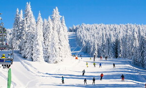
Volcanic heights
A volcano is an opening of the Earth’s surface from where lava and gases come out at high temperatures. The structure of the volcano is the result of the continuous accumulations of erupted material, which then cools down. The following volcanoes have to be distinguished: linear volcanoes, that release large quantities of very fluid lava, that expands on wide areas. A typical example of them are Iceland volcanoes: long fractures that open on the ground, …
The creation of mountains
The origin of mountains (orogenesis) occurs after tectonic movements make rock layers fold and overlap. All the Earth’s surface, the lithosphere, is divided into rigid areas called continental plates and oceanic plates. These lithospheric plates continuously move and whenever they bump into each other, they form mountain chains. The Andes Cordillera started to form 250 – 200 million years ago after the crash between an oceanic plate (Nazca plate) and a continental plate (South-American plate)…
Change the shape of mountains
As a consequence of rain and storms, water fell in a more or less uniform way down the slopes and the rocky walls of the mountains, changing and breaking the rocks into many fragments. Those fragments fell towards the bottom of the mountains due to the force of gravity, forming piles of debris called debris layers. Debris layers can be easily recognized at the bottom of rocky walls on the Dolomites. Chemical alterations and the degradation of rocks on a slope facilitate the force of gravity.
Climate and shape
All processes that shape the Earth’s surface are interlinked and connected to climatic conditions. As a consequence, they are typical of some areas on the Earth. The Mediterranean area, the Polar area, the Tropical area, etc. are named morphoclimatic zones, and are characterized by particular exogenous and climatic factors. Hot-wet regions are characterized by plenty of water and high temperatures that provoke intense processes of chemical alterations…
River and lake landscape
As a consequence of rainfalls, the waters that runs on the soil surface forms a rivulet that, joining other rivulets, becomes a stream. While the stream runs towards the valley, it receives water from other rivers (tributaries) and runs into the track it has formed, which is called bed or riverbed. The flow of a river has different gradients: the river is flatter as it gets towards its mouth. Suddenly, the gradient can increase if the riverbed is made of more compact and non-erodible rocks.
Karst landscape
The word karst derives from the name of a region, the Carso, at the border between Italy and Slovenia, which is characterized by this type of landscape. Karstik environments develop in places with calcareous rocks, which are highly soluble like limestones, dolomites and evaporitic rocks. Carbonates and evaporites are rocks made of minerals that are very soluble in the water and for this reason they are easily shaped by rainfalls. Also raindrops manage to melt these rocks and dig holes, sometimes very deep ones. The erosion of calcareous rocks in a Karstik territory is called corrosion.
Glacial landscape
A glacier is a moving mass of ice. This movement has an erosive action that shapes the Earth’s surface in cold regions. In the history of the Earth, during the Quaternary period, almost a fourth of the lands that had emerged from the sea were occupied by icecaps. Icecaps stretched to the northern regions of America, Europe and Asia that today are characterized by a mild climate. They were thousand of metres thick. When glaciers started to move forward, they deeply modified the land surface, changed river flows, stopped vegetation growth and forced animals to withdraw towards southern regions.
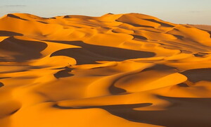
Aeolian landscape
The dry regions of the Earth are the most exposed to wind action, which blows in a regular way and with a speed that can range from few kilometres an hour to 200 kilometres an hour in case of a hurricane or a typhoon. Compared to water, the wind transports lighter fragments: sands and silts are transported by wind that exceeds 30-40 kilometres an hour. Trees, bushes and grass create obstacles to the wind. Also the presence of water makes soil particles heavy and hinders their transport.
Coastal landscape
The coast is a strip of soil between the mainland and the sea. The coast is constantly shaped by the action of the sea (waves and tides), the wind and atmospheric agents. We do not have to forget that some organisms, such as corals and algae, can destroy or build a part of the coastal landscape. Coasts can be low or high, rocky or sandy. High and rocky coasts are characterized by steep cliffs whose base is excavated by the waves. This can favour the collapse of the higher walls and therefore the withdrawal of the coast.
Industrial landscape
Industrial landscapes are obviously typical of those areas where industrial activities are very intense. Therefore it is necessary to make a distinction between industrialized and poorly-industrialized countries. The latter are located in the so-called South of the world. They are scarcely developed and their populations live in poverty. Instead, the North of the world is populated by highly industrialized countries, the rich ones, i.e. North America, Western Europe, Japan. Also Australia and New Zealand can be included in this group.
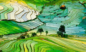
Agricultural landscape
As agriculture is the first human activity, agricultural landscapes are spread in all continents and populations. Like the industrial landscape, agricultural landscapes are not equally distributed between the developed and underdeveloped world. North America and Europe are characterized by a wide presence of rural landscapes, with intensive agriculture. In these areas, large agricultural fields are subject to a periodic rotation of crops. In this way, by using modern equipment, huge quantities of produce are exported and devoted to industrial production.
A constant evolution
Mountainous reliefs constitute an important element in our country’s scenery: mountains are visible from any point of our Peninsula, even at the center of the Padana Plain, even if often hidden by fog! It’s easy therefore for us to consider mountainous reliefs like something that is fixed and unchangeable, that has always existed and always will exist, but this is not so. Geologically speaking, our mountains are very young and they have been part of the Italian scenery only for 100 million years, a relatively short time in geological history.
How is a mountain chain made?
Mountain chains look like elongated belts, aften arched, of reliefs and successions of high peaks, bordered at the margins by flat areas. You can distinguish an “internal” zone within the chain, less deformed, and an “external” one, towards which goes the alteration process. The external zone, not yet altered, towards which moves the chain, is called foreland. Between the foreland and the chain is the foredeep, a depression below which the subduction of one of the two plates takes place: it is here, in the foredeep, that the majority of the detritus and sediments produced by the dismantling of the chain settles.
Geological history of Italy
If we could observe Italy as it was 250 million years ago, we would surely have great difficulty in recognising the places and sceneries that are so familiar to us today! The continents were grouped in the big Pangea mass, in which opened a great channel, the Tethys Sea. Our country used to be in the Western corner of this big gulf, underneath the waters of a shallow sea (200-300 m), very similar to today’s Adriatic, the margins of which used to have a landscape similar to the Bahamas carbonate platforms. This ancient sea’s deposits are still found in the sedimentary sequences of the Alps and Appennines.
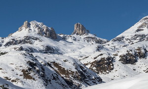
A short history of the Alps
The Alps stretch for about 1000 km, with a width of 150-200 km, and constitute an arc that separates geographically our country and the Mediterranean area from the rest of Europe. The Alps continue towards NE with the Carpati, in the heart of Europe, and towards SE with the Dinaride chain, that descends from Istria and Croatia towards Greece. Towards W the Alpine chain arches and comes into contact with the Appenninic chain in correspondence with an important tectonic lineament, the Sestri-Voltaggio Line.
Brief history of the Appennines
If the Alps constitute the Northern border of our country, the Appenninic chain forms the peninsula’s “backbone”: it extends towards NNW SSE, from Genova where it grafts with the Alpine chain along the Sestri-Voltaggio Line, until the Sibari Plain in Calabria where after a short interruption due to the wedging of the Arco Calabro bloc, it continues in the Sicilian mountains with a NE-SW trend and the connects with the Maghrebide chain and the Tellian Atlas in Tunisia, Algeria and Marocco. The Appennines’ history is also long and complex, but in short it can be reconnected to the rotational Eastern movements of the Corsica-Sardinian Bloc, contemporaneous to the collision of the European and African plates, which was creating the Alpine chain in the North.
Oligocene and erosion
From Oligocene to this day, a period of about 25 My, it has been calculated that the average rise of the Alpine chain has been of about 1 mm/y: this means that, if there had not been erosion processes, the peaks of the Alps could now reach the incredible height of 25.000 m! It also means that, during the course of a human life, mountains like Cervino or M. Bianco rise about 7-8 cm: too little to observe with a naked eye, but still sufficient for geophysical measures to quantify the deformations.
The Padana Plain: flat only on the surface
The Padana Plain extends to the S of the Alps and separates it from the Appennines: flat and monotonous on the surface, in reality it hides a very complex and active geological structure. It constitutes, in fact, the foredeep of the central part of the Alpine chain, but also that of the younger Appenninic chain: it is therefore the area where two important chains, still in the making, stand one in front of the other. The result is that underneath the Padana Plain, below a 300-400 m cover of river and lake sediments, starting from Pliocene (3,9 My) big folds and tectonic slices have formed, and continue to form and stack one on top of the other.
Causes
Even though gravity is the main ‘motor’ of landslides, there are numerous factors, mainly of geological and climatic origin, that make a soil or a mountain more liable to landsliding: these are the so-called predisposing factors. Among these, of particular importance are the geological nature of the material (the kind of rock, its resistance, if it is made up of coherent material like rock or loose material, like a sediment or soil), if it is fractured or modified – this would influence its resistance (intuitively, compact rock without fractures will have a greater resistance than a heap of stones made of the same material), but also the gradient of the slope on which they are situated plays an important part.
Many processes, many types
The conditions and causes for a landslide are so many and so varied that there are many different types of landslides. Their classification is, therefore, very difficult and complex. They can, however, be divided into (not taking the volume of the moving material into consideration): falls, slides and flows. Falls occur on rocky mountain slopes with the detachment of blocks of rock, like those taking place on many mountain tops in the Dolomites at present…
What a landslide looks like
Even though a landslide often appears to be a very rugged and complex area, usually the scar is clearly visible, bounded by the scarp that marks the area where the detachment of the sides has taken place, often crowned and surrounded by fractures and cracks that have opened uphill and by a slump block made up of accumulated material. Whatever the kind of landslide, usually the latter is an irregular topographical area, with numerous depressions, often with a ‘toe’ that spreads at the base covering the terrain on which the landslide has slipped.
Fast and slow movements
Landslides are often characterized by sudden movement, often at great speed, in which great masses of material are dragged downhill. These are surely the most dangerous landslides, because they rarely give the affected populations time to get out of danger. However, there are other movements that are very slow, which imperceptibly influence the lives of human beings, and are inexorable and unrelenting. Often they involve enormous masses of rock, at times, entire mountains, and take the name of deep-seated gravitational slope deformations.
How the italian territory is affected
Italy is one of the countries with a high risk as far as landslides are concerned. This derives from the geological characteristics of our territory. In the first place, as much as 77% of our territory is made up of mountainous and hilly areas, this is a destabilising factor in itself. In addition, the territory is geologically young and very active, with many areas presently rising, like many parts of the Alps and Apennines, and with numerous volcanic areas with high seismic risk, all conditions that increase the risk of landslides.
Risk or danger?
When studying landslide phenomena, it is opportune to distinguish between the risk that is tied to the probability that an event may occur, and the danger of the event, which instead is tied to material damages that the phenomenon can provoke, and the toll of human lives. Enormous landslides in uninhabited areas modify the landscape irreversibly, but are not particularly dangerous, instead, a single mass that balances on a mountain-side above an urban centre can be very dangerous, even though the volume is small, because it might fall directly on things or people, provoking severe economic and human damages.
Studying landslides
Often landslides are highlighted in the headlines of the news, described as sudden catastrophic events that occur with no warning signals on the population that is totally unaware of the danger. Actually, due to all the considerations listed above, landslide events are certainly not unpredictable and their unpredictability is only the result of a poor knowledge or a questionable sensational policy of the information media. As in the case of earthquakes, what cannot be foreseen is the exact time in which the landslide will occur…
Defences
Structures built to defend the land from landslides are constructed with the aim of restoring stability of the slopes, eliminating the causes of the movement or reinforcing the materials. For this purpose, different structures can be constructed as a defence, depending on the type of landslide, the geological characteristics, the terrain and the risk:danger ratio. The aim of some of the defensive structures is to eliminate or minimize some of the triggering causes, as for example the creation of drainage structures to take away excess water from land that is at risk by putting the water courses on a steady state, growing new plants and new trees, …
Go to the full text
Prevention
Two main attitudes are observed when in the face of natural disasters. On one hand there is a tendency to minimize or ignore the risks till the calamity takes place, and then rapidly seek shelter or accept the whims of nature with atavic resignation. On the other hand there is an attempt to understand how the natural systems work, and to foresee the possible situations of risk, to prevent the occurrence of the phenomenon by avoiding behaviours that can aggravate the situation, creating opportune protection and monitoring structures, predisposing evacuation plans in case of real danger.
The construction of big works
The building of dikes, piers, roads, energy plants, etc. modifies the landscapes and interferes with natural processes. These changes have to be kept in mind during the first planning stages. Let us image to stop a river flow by building a dike. We will have to take the following aspects into consideration: the stability of the building; the quantity of river sediments that will not reach the sea but that will deposit on the dike lake; the danger of erosion for the beaches that are located close to the river mouth.
Surface water erosion
In order to stop surface water erosion it is necessary to reduce water speed. At this regard and in order to protect a riverbed, men build river bridles, i.e. a series of steps along the river flow. In order to prevent floods, instead, artificial banks are built. When building them, it is important to calculate the natural space the river needs in order to let floodwater drain off. In order to reduce the quantity of water of a riverbed during a flood, water tanks (that can provisionally transmit a certain quantity of water) and drainage channels (that divert the river flow) are designed.
How to protect from landslides
Landslides provoke serious damages to things and people and they can be prevented by consolidating the area at risk. First of all it is necessary to detect the sliding land and avoid building or excavating in the area. Moreover, it is necessary to prevent big quantities of water from running on the surface of this land: drains have to be built and vegetation growth is to be encouraged. Support walls or gabionades are built to contain material that otherwise would move to the bottom of the slope.
Environmental Impact Assessment
The Environmental Impact Assessment was born in the United States in 1969 from the National Environment Policy Act (NEPS) and it anticipated, by almost ten years, the basic principle of the concept of Sustainable Development, defined as a “sustainable economic development that meets present needs without compromising future generations ability to meet their own needs” enunciated by the World Commission on Environment and Development, Our Common Future, in 1987. In Europe, this procedure was introduced by EEC Directive 85/337/EEC, and was subsequently implemented in the regulations of the Member States, soon becoming a fundamental instrument in environmental policies.
Floods
In Italy watercourses are often characterized by dry periods and short but intense floods due to heavy precipitations. The water rise provokes an increase in the water running speed. As a consequence, the water goes out of its banks. Deforestation, fires, buildings in risky areas are some of the reasons why these phenomena occur. The waters of the Po river run inside the artificial banks that stretch for 510 km, out of 652 km of the river total length.