Cryosphere

Similarly to the hydrosphere, that includes all the planet’s water in the liquid state, in any area and in any form that it may be present, or to the biosphere that consists of all the living organisms whatever kingdom they belong to, and whatever area they may live in, the cryosphere includes all the Earth’s ice.
When we think of ice, the image that comes to our mind is that of the clean twinkling stretches of the glaciers, however the Earth’s ice may be found in many other forms, which at times are also well “hidden” and, surprisingly, also in unexpected geographic areas such as the centre of Africa!
Almost all the Earth’s ice consists of ice from glaciers or sea ice. Large quantities of frozen ice can also be found in the permafrost areas, trapped in the ground and in the rock crevices, but, as they cannot be seen directly, it is very difficult to quantify their volume and extension. Also caves can contain ice deposits, at times with the characteristics of glacier ice, more often with ice that formed by freezing: generally these are rather small quantities, but they represent a very precious data bank of the climate of the past.
Related topic
Where can they be found?
Glaciers may exist only on two conditions: the first, which is quite obvious, is that the annual temperatures must be below zero for a certain period of the year, so that ice can be preserved, the second, which is less intuitive, but equally indispensable, is that a sufficient amount of snow required to form a certain mass of ice must fall. In fact, just as excessive heat does not allow the preservation of a glacier, likewise, scarce precipitations prevent the formation of a glacier even where temperatures are below zero: for this reason, in the Polar desert areas glaciers do not form.
The Earth’s ice
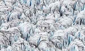
Clear distinction must be made between the ice covering lands above sea level and sea ice floating in the Polar seas. In order to be considered a glacier, the ice must move under the thrust of its own weight: therefore sea ice or icebergs, even though they move at times, cannot be considered glaciers, as their movement is passive, generated by sea currents, wave motion or winds. Even though they are formed by the same material, the Earth’s glaciers are very different one from the other, in extension, ice-thickness, geographical position and climate regime, topographical situation and shape.
How much ice is there on the Earth?
Most of the Earth’s ice that we see is to be found in large masses of “nearly” pure ice (due consideration must be given to the aspects described above): ice-sheets and glaciers of various types, ice shelves and sea ice packs. It is quite easy to calculate the surface of the areas covered with ice: it has been calculated that this amounts to approximately 15 million km2, equal to one tenth of the surface of the Earth’s emersed land. It is more difficult, on the contrary, to calculate the volume of ice because the thickness of the entire covered area must be known.
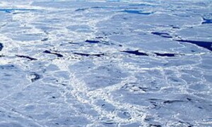
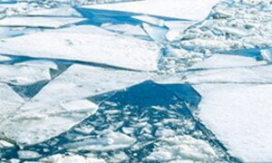
Sea ice: cold polar seas
Sea ice has a completely different origin from glacier ice. Sea ice in fact forms due to direct freezing of sea water, when the temperature of the air remains below -1.8°C for a few days.
Its formation, which is seasonal, is spectacular: at first ice needles and thin plates form. These, floating, give the sea surface a particular “oily” appearance, the so-called greasy ice. The crystals aggregate, originating slabs that get increasingly thick, and due to the continuous collisions provoked by wave motion, they take on a circular form with raised borders, which look like large white pancakes, from which the name pancake ice.
Permafrost: frozen ground
When the mean annual temperatures of the air remain below zero for long periods of time, the water in the ground is always in the solid state, and the land is permanently frozen. This state is named permafrost (i.e. permanent ice). The land, hardened and without any liquid water, is made up of mineral particles (particles of soil, grains and rock debris of various sizes) cemented together by ice. The depth of the ice depends on how cold the climate is, and can reach many dozens of metres.
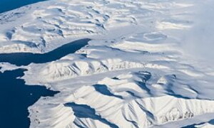
Ice-sheets: continental glaciers
Ice-sheets, also known with the Norwegian term, inlandsis, continental ice, are expanse of ice with a surface area of over 50,000 km2, where ice buries and masks the underlying relief that does not influence its trend. The surface is generally mildly convex, like a kind of very flat dome, from which higher peaks of the underlying relief may emerge; these are named nunatak, an Inuit term that means “isolated mountain”. The central, more raised sector, of an ice-sheet is known as the dome. Ice caps are similar to ice-sheets but their size is smaller.
Ice shelves
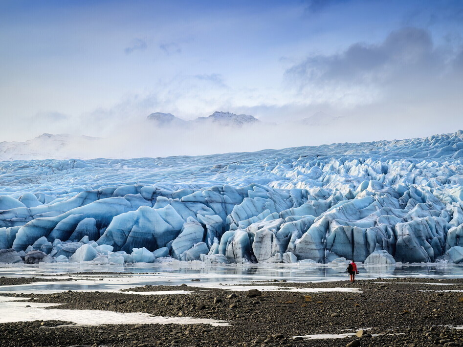
When a glacier reaches the sea, it stretches into a floating snout. The confluence of various floating snouts gives origin to the formation of an ice shelf: a kind of flat shelf that floats on the sea and is anchored to the ground by the tongues that feed it. The most extensive ice shelf is the Ross Ice Shelf in Antarctica, with an average thickness of 300 m and a surface area of 472,960 km2, equal to the area of France – it is bounded on the sea-front by ice walls up to 200 m high.
Icebergs
Icebergs (from ice and berg, mountain, mountains of ice) form when a glacier descends to the sea or to a lake, the terminal part of the snout starts floating when it comes into contact with water. Because of a phenomenon known as calving, large fractures form in the mass of ice, with the consequent detachment of portions of different sizes. The shape of this kind of iceberg is generally irregular, and the surface is jagged, tormented…
Mountain glaciers
These, as their definition describes, are bodies of ice that are found in the mountains. These can be classified in many ways, bearing in mind their geographical position, shape, temperature. Size is not a criterion used to distinguish these glaciers, some of them are very small, as the Calderone glacier on the Gran Sasso d’Italia mountain in the Apennines, which is little more than a thin strip of old snow (at present it is considered practically “extinct”), or the gigantic ice “rivers”, that are dozens or even hundreds of kilometres long.
Related topic
The Antarctic
The “Antarctic ice sheet” actually consists of two distinct ice-sheets. A Western one, which is smaller and is anchored to a group of islands, and an Eastern one, which is very vast and which, alone, accounts for 78% of the world’s glaciers; the latter covers the Antarctic continent and rises with a number of domes, to heights over 4,000 m. The two ice-sheets are separated by the Transantarctic mountain chain, which has peaks over 4,000 m high. The Western ice-sheet has a maximum thickness of 3.5 km, and its base is prevalently below sea level, while the Eastern ice-sheet reaches thicknesses up to 4.5 km and it is prevalently above sea level.
The Greenland Ice Sheet
Greenland, the green land, named this way by Eric the Red in the 10th century, to encourage the Vikings to colonize the land. At the time, in fact, it was truly green, however the subsequent advance of ice forced the colons to abandon the island: only the Inuits survived the Little Ice Age. The Greenland Ice Sheet occupies seven eights of the island, with a surface area of 1.73 million km2 and a volume of 2.6 million km3, leaving only a small mountainous coastal strip that limits and “contains” the ice-sheet. The ice thickness is 1,790 m on average, but in some parts it is over 3,000 m, culminating in two domes that are 3,300 m high.
Glaciers in the Alps
Glaciers in the Alps account, on the whole, for less than 0.02% of the world glaciers, but are very important because it is here that the first glaciology studies were started, and we have a lot of information about these glaciers over a long period of time. The 1989 International Glacier Registry recorded 5,154 glaciers in the Alps with a surface of a little less than 3,000 km2, of which the largest are in the Northern slopes, where large valley glaciers form frequently. The largest glaciers are in Switzerland in the Bernese Alps, where there is also the largest Alpine glacier, the Aletschglätscher…
Glacier inventories
In Italy, the Italian Glaciology Committee, in collaboration with the Consiglio Nazionale delle Ricerche, (the Italian National Research Council) published the Italian Glacier Inventory in the years between 1959 and 1962, and up-dated it in 1989. It is a fundamental document that clearly shows the situation of Italian glaciers and is complete with historical data and images of great importance.
Melting water on a glacier surface collects in small seasonal water streams that erode their bed in the ice, and are called bédières (a French term): in fact, ice is impermeable and does not allow the water to seep in deep. However, glaciers are characterized by a number of fractures that run across the surface. Through these fractures surface water can filter in and flow within the glacier.
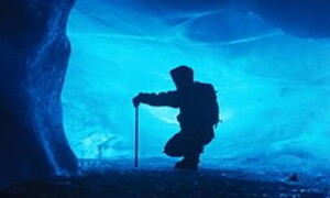
Liquid water is obviously warmer than the ice it comes into contact with, and determines its melting, creating a system of empty spaces, underground passages, shafts and galleries that are similar to the systems of caves in the rock. The difference is that caves in the rock are created by chemical processes, (dissolving limestone) while ice caves are formed due to a physical process (ice melting). The ice cavities form in all the glaciers that are “warm” enough for water in the liquid state to be present. The formation of ice caves is very rapid, and can be observed, one may say, in “real time”: the cavities form and change during the course of a few weeks or a few days and this offers the opportunity to understand analogous forms that developed, in much longer times, in the rocks. For ice caves to form, ice, which is impermeable, must be broken by fractures that enable water to penetrate deeply and, as it melts the surrounding ice, to widen these fractures giving rise to the formation of shafts and galleries, which may even be several metres in diameter.
On the surface shafts and sinkholes are noted, known as glacier sinkholes or moulins (glacier mills), because the water spins like in a water mill, through which water seeps into the depths of the glacier. Due to the effect of gravity, water tends to follow a way as vertical as possible, creating large shafts and deep gorges in the ice that is fractured due to the enormous tensions that develop within its mass, and flows slowly under the thrust of its own weight. Beyond a certain depth (approximately 150-200 m, and it is equal for all glaciers, independent of their thickness), ice becomes plastic and behaves like an impermeable barrier that prevents water from seeping more deeply in its course: thus horizontal galleries are formed, these are completely flooded and convey water from the sinkholes right to the front where, due to the presence of deep crevasses, it can reach the base of the glacier, and then flow outside through the “mouths” of the glacier, with galleries that can be several metres wide, out of which the turbulent greyish waters of the glacier drainage channels flow. The “mouths” of a glacier often really look like large “mouths”, similar to the opening of an oven, from which the toponyms of some of the Alpine glaciers derive (oven is forno in Italian) (The Forni Glacier in the Ortles-Cevedale group, the Forno Glacier in the Bregaglia valley, Switzerland).
Related topic
Evolution of a cave
A moulin forms in a precise point of the glacier where fractures are favourable, and like whatever is on top of or inside the glacier, it is then slowly dragged downstream by the movement of the ice: next spring a new moulin will form in the same point, and the old moulin, deprived with water, which has been captured by its younger upstream companion, will slowly close, due to the plastic swelling of the ice, till it finally disappears after a few years, while new moulins continue to form further upstream. For this reason moulins are almost always in groups, aligned in a precise direction and always in the same point of the glacier.
Two worlds not to be confused
Many Karst caves, dug into the rock, contain ice inside, in amounts that can be also considered abundant. These must not be confused with ice caves that are formed entirely within the glacier. The mechanisms that lead to the formation of ice ina cave are numerous and very complex. Seasonal ice may form in winter because the water that percolates through the crevices freezes near the openings, where the temperatures of the cave are influenced by the cold external temperature.
Speleology in the cold
Since the first explorations on the Alpine glaciers, alpine climbers and experts have observed the spectacular display, which is both fascinating and frightening, of glacial sinkholes. Moulins were seen as bizarre natural anomalies, that drew attention and fear, due to the depth that at times could not be measured, and because of the violence with which the waters seemed to be sucked into the glacier’s stomach: for over a century many wondered about the origin of these structures and the invisible course of water within the glaciers (the first recorded explorations date back to the end of 1800 on the Mer de Glace in France), however it is only since the Eighties that technical progress enabled direct exploration of glacial sinkholes, in safe conditions and relatively easily.
Studying ice caves
The entire glacier body moves continuously downstream and in this movement it drags whatever is on its surface and inside. Therefore also the ice cave systems move downward together with the glacier in which they have formed. By studying the mechanisms by which these cavities form, it has been possible to observe that a new sinkhole forms every year in the same point of the glacier, above a fixed point of the substratum. It is as if in that point there were particular conditions, due, for example, to the characteristics of the substratum, that determine the formation of a moulin in the ice that is in that point at that time.